Colorado natural hazard risk by county
Colorado has about $2.08 billion in modeled expected annual loss across 64 counties. The state accounts for 1.4% of the national modeled loss total. Its total ranks #26 among 56 state-level entries by modeled loss. FEMA published these 64 county estimates in its December 2025 National Risk Index. The modeled $2.08 billion annual average does not predict loss in any one year.
- Modeled expected annual loss
- $2.08 billion / year
- Share of US loss
- 1.4%
- State loss rank
- #26 of 56
- Largest modeled-loss hazard
- Riverine Flood
Colorado county modeled loss
- Positive estimates to $4.6 million
- Above $4.6 million to $8.9 million
- Above $8.9 million to $16.6 million
- Above $16.6 million to $34.7 million
- Above $34.7 million to $231.4 million
- No FEMA estimate
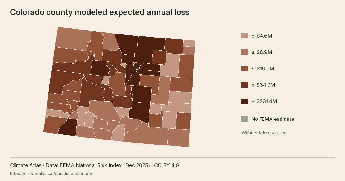
Colorado counties use five within-state quantile classes of modeled expected annual loss. Darker rust means a larger estimate; outlined counties have detailed pages.
View chart data
| County | Modeled expected annual loss (USD/year) | Overall risk rating |
|---|---|---|
| Conejos County, CO | 5,237,169.08 | Very Low |
| Jackson County, CO | 4,918,653.86 | Very Low |
| Archuleta County, CO | 8,282,920.68 | Very Low |
| Washington County, CO | 4,348,037.15 | Very Low |
| Garfield County, CO | 29,571,351.54 | Relatively Low |
| Rio Grande County, CO | 8,850,229.34 | Relatively Low |
| Morgan County, CO | 20,259,373.73 | Relatively Low |
| Elbert County, CO | 16,628,379.17 | Very Low |
| Montrose County, CO | 15,581,211.65 | Relatively Low |
| Otero County, CO | 11,901,089.62 | Relatively Low |
| Teller County, CO | 16,818,497.32 | Very Low |
| Phillips County, CO | 6,918,070.78 | Very Low |
| Yuma County, CO | 15,547,372.14 | Very Low |
| Pueblo County, CO | 48,414,654.77 | Relatively Moderate |
| Alamosa County, CO | 7,920,978.60 | Very Low |
| Baca County, CO | 4,714,405.92 | Very Low |
| Montezuma County, CO | 12,351,479.87 | Relatively Low |
| Arapahoe County, CO | 171,506,711.72 | Relatively Moderate |
| Mineral County, CO | 4,555,656.44 | Very Low |
| Dolores County, CO | 4,440,888.88 | Very Low |
| Jefferson County, CO | 231,403,490.65 | Relatively High |
| Delta County, CO | 14,075,445.38 | Relatively Low |
| Grand County, CO | 20,267,986.79 | Relatively Low |
| Saguache County, CO | 5,044,667.98 | Very Low |
| Summit County, CO | 29,532,888.62 | Relatively Low |
| Gunnison County, CO | 21,274,976.70 | Relatively Low |
| Costilla County, CO | 1,932,764.41 | Very Low |
| Weld County, CO | 104,694,892.04 | Relatively Moderate |
| Las Animas County, CO | 6,844,595.78 | Very Low |
| Routt County, CO | 16,196,157.54 | Very Low |
| Douglas County, CO | 113,524,496.56 | Relatively Moderate |
| Rio Blanco County, CO | 10,944,615.94 | Very Low |
| Broomfield County, CO | 17,098,679.23 | Very Low |
| Denver County, CO | 221,992,551.14 | Relatively High |
| Boulder County, CO | 125,308,344.76 | Relatively Moderate |
| Larimer County, CO | 126,514,415.97 | Relatively Moderate |
| Crowley County, CO | 2,259,043.17 | Very Low |
| Custer County, CO | 4,068,479.83 | Very Low |
| El Paso County, CO | 212,634,039.56 | Relatively Moderate |
| Gilpin County, CO | 4,503,801.52 | Very Low |
| Huerfano County, CO | 5,624,574.82 | Very Low |
| Ouray County, CO | 9,322,162.55 | Very Low |
| Cheyenne County, CO | 2,961,029.76 | Very Low |
| Moffat County, CO | 7,019,242.98 | Very Low |
| Pitkin County, CO | 26,359,343.63 | Relatively Low |
| Prowers County, CO | 10,252,817.14 | Relatively Low |
| San Juan County, CO | 6,943,481.58 | Very Low |
| La Plata County, CO | 39,500,309.07 | Relatively Low |
| Hinsdale County, CO | 1,840,433.47 | Very Low |
| Kit Carson County, CO | 10,349,768.11 | Very Low |
| San Miguel County, CO | 10,021,082.45 | Very Low |
| Clear Creek County, CO | 20,677,324.15 | Relatively Low |
| Kiowa County, CO | 3,311,856.55 | Very Low |
| Park County, CO | 10,914,465.31 | Very Low |
| Lake County, CO | 4,393,753.97 | Very Low |
| Lincoln County, CO | 4,587,986.26 | Very Low |
| Adams County, CO | 130,863,113.09 | Relatively Moderate |
| Eagle County, CO | 48,499,059.62 | Relatively Low |
| Logan County, CO | 18,028,879.47 | Relatively Low |
| Sedgwick County, CO | 3,692,580.75 | Very Low |
| Chaffee County, CO | 19,972,536.64 | Relatively Low |
| Fremont County, CO | 22,422,062.45 | Relatively Low |
| Mesa County, CO | 34,730,152.82 | Relatively Low |
| Bent County, CO | 4,113,849.26 | Very Low |
Reading the Colorado county map
The map groups 64 county estimates into five within-state loss classes. Each boundary follows the county geography, while the fill represents modeled dollars per year. The class breaks are calculated from Colorado county values, so a matching shade on another state page need not represent the same amount. Grey marks unmatched geography or an unavailable estimate. Outlined counties link to the detailed profiles available in this release; counties without profiles still contribute to the state totals.
Together, the three largest estimates account for 32.0% of Colorado modeled annual loss. Their combined population represents 35.1% of the state source population. Comparing these two shares helps distinguish the concentration of modeled dollars from the concentration of residents. Neither share identifies the exposure of an individual address, and the map does not show the location of damage within a county.
Ten largest county loss estimates
Jefferson County, CO has the largest modeled expected annual loss in this comparison, about $231.4 million.
View chart data
| Place | USD / year |
|---|---|
| Jefferson County, CO | 231,403,490.65 |
| Denver County, CO | 221,992,551.14 |
| El Paso County, CO | 212,634,039.56 |
| Arapahoe County, CO | 171,506,711.72 |
| Adams County, CO | 130,863,113.09 |
| Larimer County, CO | 126,514,415.97 |
| Boulder County, CO | 125,308,344.76 |
| Douglas County, CO | 113,524,496.56 |
| Weld County, CO | 104,694,892.04 |
| Eagle County, CO | 48,499,059.62 |
County totals beside population
Jefferson County, CO combines about $231.4 million in modeled annual loss with 582,825 recorded residents. Dividing those figures gives about $397 per resident, compared with $361 statewide. On this population-adjusted measure, the county places #51 among the 64 state county records. This ratio spreads all modeled losses across residents for comparison; it is not a household bill, an insurance premium or an estimate of personal damage.
Denver County, CO combines about $222.0 million in modeled annual loss with 715,210 recorded residents. Dividing those figures gives about $310 per resident, compared with $361 statewide. On this population-adjusted measure, the county places #58 among the 64 state county records. This ratio spreads all modeled losses across residents for comparison; it is not a household bill, an insurance premium or an estimate of personal damage.
State hazard loss mix
Riverine Flood leads the modeled expected annual loss mix; bar lengths share a zero baseline.
View chart data
| Hazard | USD / year | Share |
|---|---|---|
| Riverine Flood | 960,202,523.61 | 46.1% |
| Hail | 341,473,279.92 | 16.4% |
| Wildfire | 211,174,415.25 | 10.1% |
| Tornado | 188,310,899.06 | 9.0% |
| Cold Wave | 128,789,620.06 | 6.2% |
| Lightning | 85,111,058.70 | 4.1% |
| Other | 165,847,047.21 | 8.0% |
El Paso County, CO combines about $212.6 million in modeled annual loss with 729,693 recorded residents. Dividing those figures gives about $291 per resident, compared with $361 statewide. On this population-adjusted measure, the county places #59 among the 64 state county records. This ratio spreads all modeled losses across residents for comparison; it is not a household bill, an insurance premium or an estimate of personal damage.
Where the leading hazards are concentrated
For riverine flooding, El Paso County, CO contributes 11.0% of the state hazard total. The next county, Denver County, CO, contributes about $93.6 million annually, compared with $105.2 million for the leader. Across Colorado, 64 county records have a positive modeled estimate for this hazard. The remaining counties together account for about $761.4 million after those two leading estimates. The state places #22 of 56 state-level entries for this hazard. Its share of the state loss mix is 46.1%. These comparisons describe modeled losses rather than future events.
County hazard rating counts
- Very Low
- Relatively Low
- Relatively Moderate
- Relatively High
- Very High
- No rating
Colorado has 64 county records in each row. Each bar shows the FEMA risk rating distribution for one of the three largest modeled-loss hazards.
View chart data
| Hazard | Rating | Count |
|---|---|---|
| Riverine Flood | Very Low | 29 |
| Riverine Flood | Relatively Low | 20 |
| Riverine Flood | Relatively Moderate | 12 |
| Riverine Flood | Relatively High | 3 |
| Riverine Flood | Very High | 0 |
| Riverine Flood | No rating | 0 |
| Hail | Very Low | 26 |
| Hail | Relatively Low | 12 |
| Hail | Relatively Moderate | 15 |
| Hail | Relatively High | 7 |
| Hail | Very High | 4 |
| Hail | No rating | 0 |
| Wildfire | Very Low | 18 |
| Wildfire | Relatively Low | 28 |
| Wildfire | Relatively Moderate | 13 |
| Wildfire | Relatively High | 5 |
| Wildfire | Very High | 0 |
| Wildfire | No rating | 0 |
For hail, Denver County, CO contributes 21.2% of the state hazard total. The next county, Arapahoe County, CO, contributes about $64.0 million annually, compared with $72.4 million for the leader. Across Colorado, 64 county records have a positive modeled estimate for this hazard. The remaining counties together account for about $205.0 million after those two leading estimates. The state places #2 of 56 state-level entries for this hazard. Its share of the state loss mix is 16.4%. These comparisons describe modeled losses rather than future events.
For wildfires, Jefferson County, CO contributes 23.1% of the state hazard total. The next county, El Paso County, CO, contributes about $41.6 million annually, compared with $48.7 million for the leader. Across Colorado, 64 county records have a positive modeled estimate for this hazard. The remaining counties together account for about $120.8 million after those two leading estimates. The state places #3 of 56 state-level entries for this hazard. Its share of the state loss mix is 10.1%. These comparisons describe modeled losses rather than future events.
For tornadoes, Denver County, CO contributes 14.9% of the state hazard total. The next county, El Paso County, CO, contributes about $25.3 million annually, compared with $28.0 million for the leader. Across Colorado, 64 county records have a positive modeled estimate for this hazard. The remaining counties together account for about $135.0 million after those two leading estimates. The state places #23 of 56 state-level entries for this hazard. Its share of the state loss mix is 9.0%. These comparisons describe modeled losses rather than future events.
For cold waves, Adams County, CO contributes 16.6% of the state hazard total. The next county, Weld County, CO, contributes about $18.9 million annually, compared with $21.4 million for the leader. Across Colorado, 63 county records have a positive modeled estimate for this hazard. The remaining counties together account for about $88.5 million after those two leading estimates. The state places #27 of 56 state-level entries for this hazard. Its share of the state loss mix is 6.2%. These comparisons describe modeled losses rather than future events.
For lightning, Jefferson County, CO contributes 13.4% of the state hazard total. The next county, Douglas County, CO, contributes about $7.5 million annually, compared with $11.4 million for the leader. Across Colorado, 64 county records have a positive modeled estimate for this hazard. The remaining counties together account for about $66.2 million after those two leading estimates. The state places #3 of 56 state-level entries for this hazard. Its share of the state loss mix is 4.1%. These comparisons describe modeled losses rather than future events.
Colorado hazard totals and county comparisons
| Hazard | Modeled annual loss | State share | VH / RH counties | Largest county | US state rank |
|---|---|---|---|---|---|
| Riverine Flood | $960.2 million | 46.1% | 0 / 3 | El Paso County, CO | #22 of 56 |
| Hail | $341.5 million | 16.4% | 4 / 7 | Denver County, CO | #2 of 56 |
| Wildfire | $211.2 million | 10.1% | 0 / 5 | Jefferson County, CO | #3 of 56 |
| Tornado | $188.3 million | 9.0% | 0 / 9 | Denver County, CO | #23 of 56 |
| Cold Wave | $128.8 million | 6.2% | 0 / 6 | Adams County, CO | #27 of 56 |
| Lightning | $85.1 million | 4.1% | 10 / 14 | Jefferson County, CO | #3 of 56 |
| Strong Wind | $44.3 million | 2.1% | 0 / 10 | Weld County, CO | #26 of 56 |
| Earthquake | $41.4 million | 2.0% | 0 / 0 | Denver County, CO | #33 of 56 |
| Drought | $21.9 million | 1.1% | 0 / 4 | Baca County, CO | #19 of 56 |
| Winter Weather | $20.5 million | 1.0% | 6 / 4 | El Paso County, CO | #8 of 56 |
| Heat Wave | $12.6 million | 0.6% | 0 / 0 | El Paso County, CO | #40 of 56 |
| Avalanche | $11.2 million | 0.5% | 9 / 14 | Pitkin County, CO | #5 of 56 |
| Landslide | $10.9 million | 0.5% | 0 / 5 | Mesa County, CO | #5 of 56 |
| Ice Storm | $2.9 million | 0.1% | 0 / 0 | Weld County, CO | #37 of 56 |
| Volcanic Activity | $3,000 | 0.0% | 0 / 0 | Eagle County, CO | #10 of 56 |
Hazard shares show which modeled expected annual losses dominate the state total; ranks compare state totals for the same hazard.
Colorado hazard totals combine the county estimates. The largest county column identifies concentration within each hazard; the state rank compares the same hazard across state-level entries.
Colorado county loss totals
| County | Risk index rating | Modeled annual loss | Largest hazard |
|---|---|---|---|
| Jefferson County | Relatively High | $231.4 million | Riverine Flood |
| Denver County | Relatively High | $222.0 million | Riverine Flood |
| El Paso County | Relatively Moderate | $212.6 million | Riverine Flood |
| Arapahoe County | Relatively Moderate | $171.5 million | Hail |
| Adams County | Relatively Moderate | $130.9 million | Hail |
| Larimer County | Relatively Moderate | $126.5 million | Riverine Flood |
| Boulder County | Relatively Moderate | $125.3 million | Riverine Flood |
| Douglas County | Relatively Moderate | $113.5 million | Riverine Flood |
| Weld County | Relatively Moderate | $104.7 million | Riverine Flood |
| Eagle County | Relatively Low | $48.5 million | Riverine Flood |
| Pueblo County | Relatively Moderate | $48.4 million | Riverine Flood |
| La Plata County | Relatively Low | $39.5 million | Riverine Flood |
| Mesa County | Relatively Low | $34.7 million | Riverine Flood |
| Garfield County | Relatively Low | $29.6 million | Riverine Flood |
| Summit County | Relatively Low | $29.5 million | Riverine Flood |
Show all 64 counties
| County | Risk index rating | Modeled annual loss | Largest hazard |
|---|---|---|---|
| Pitkin County | Relatively Low | $26.4 million | Riverine Flood |
| Fremont County | Relatively Low | $22.4 million | Riverine Flood |
| Gunnison County | Relatively Low | $21.3 million | Riverine Flood |
| Clear Creek County | Relatively Low | $20.7 million | Avalanche |
| Grand County | Relatively Low | $20.3 million | Riverine Flood |
| Morgan County | Relatively Low | $20.3 million | Riverine Flood |
| Chaffee County | Relatively Low | $20.0 million | Riverine Flood |
| Logan County | Relatively Low | $18.0 million | Riverine Flood |
| Broomfield County | Very Low | $17.1 million | Riverine Flood |
| Teller County | Very Low | $16.8 million | Wildfire |
| Elbert County | Very Low | $16.6 million | Wildfire |
| Routt County | Very Low | $16.2 million | Riverine Flood |
| Montrose County | Relatively Low | $15.6 million | Riverine Flood |
| Yuma County | Very Low | $15.5 million | Cold Wave |
| Delta County | Relatively Low | $14.1 million | Riverine Flood |
| Montezuma County | Relatively Low | $12.4 million | Riverine Flood |
| Otero County | Relatively Low | $11.9 million | Riverine Flood |
| Rio Blanco County | Very Low | $10.9 million | Riverine Flood |
| Park County | Very Low | $10.9 million | Wildfire |
| Kit Carson County | Very Low | $10.3 million | Cold Wave |
| Prowers County | Relatively Low | $10.3 million | Riverine Flood |
| San Miguel County | Very Low | $10.0 million | Riverine Flood |
| Ouray County | Very Low | $9.3 million | Riverine Flood |
| Rio Grande County | Relatively Low | $8.9 million | Riverine Flood |
| Archuleta County | Very Low | $8.3 million | Riverine Flood |
| Alamosa County | Very Low | $7.9 million | Riverine Flood |
| Moffat County | Very Low | $7.0 million | Riverine Flood |
| San Juan County | Very Low | $6.9 million | Avalanche |
| Phillips County | Very Low | $6.9 million | Drought |
| Las Animas County | Very Low | $6.8 million | Riverine Flood |
| Huerfano County | Very Low | $5.6 million | Riverine Flood |
| Conejos County | Very Low | $5.2 million | Riverine Flood |
| Saguache County | Very Low | $5.0 million | Riverine Flood |
| Jackson County | Very Low | $4.9 million | Avalanche |
| Baca County | Very Low | $4.7 million | Drought |
| Lincoln County | Very Low | $4.6 million | Riverine Flood |
| Mineral County | Very Low | $4.6 million | Avalanche |
| Gilpin County | Very Low | $4.5 million | Riverine Flood |
| Dolores County | Very Low | $4.4 million | Avalanche |
| Lake County | Very Low | $4.4 million | Avalanche |
| Washington County | Very Low | $4.3 million | Riverine Flood |
| Bent County | Very Low | $4.1 million | Riverine Flood |
| Custer County | Very Low | $4.1 million | Riverine Flood |
| Sedgwick County | Very Low | $3.7 million | Drought |
| Kiowa County | Very Low | $3.3 million | Drought |
| Cheyenne County | Very Low | $3.0 million | Drought |
| Crowley County | Very Low | $2.3 million | Riverine Flood |
| Costilla County | Very Low | $1.9 million | Riverine Flood |
| Hinsdale County | Very Low | $1.8 million | Riverine Flood |
Colorado population, values and ratings
- Population
- 5,768,835
- Building value
- $1,161.98 billion
- Agricultural value
- $9.65 billion
- Modeled loss per resident
- $361
Overall county risk ratings
- Very Low: 35
- Relatively Low: 19
- Relatively Moderate: 8
- Relatively High: 2
Colorado overall ratings describe relative county risk. Segment widths count counties, rather than residents or modeled dollars.
View chart data
| Rating | Count |
|---|---|
| Very Low | 35 |
| Relatively Low | 19 |
| Relatively Moderate | 8 |
| Relatively High | 2 |
Colorado county pages
Colorado has 1 detailed county page linked below.
Questions about Colorado
Which Colorado county has the largest modeled loss?
Jefferson County, CO leads Colorado, with about $231.4 million in modeled expected annual loss.
Which hazard leads modeled loss in Colorado?
Riverine flooding leads Colorado, at about $960.2 million annually.
What total loss does FEMA model for Colorado?
Colorado has about $2.08 billion in modeled expected annual loss.
What share of national loss belongs to Colorado?
The state accounts for 1.4% of national modeled loss.
How many counties appear in the Colorado table?
The Colorado table contains 64 counties and county equivalents.
Where does Colorado rank by modeled loss?
Colorado places #26 of 56 state-level entries by modeled expected annual loss.
Does the Colorado estimate predict next year?
The Colorado figure is a long-run modeled annual average, rather than a forecast for any single year.
Colorado county modeled expected annual loss, in five within-state quantile classes.