Ohio natural hazard risk by county
Ohio has about $3.06 billion in modeled expected annual loss across 88 counties. The state accounts for 2.0% of the national modeled loss total. Its total ranks #15 among 56 state-level entries by modeled loss. FEMA published these 88 county estimates in its December 2025 National Risk Index. The modeled $3.06 billion annual average does not predict loss in any one year.
- Modeled expected annual loss
- $3.06 billion / year
- Share of US loss
- 2.0%
- State loss rank
- #15 of 56
- Largest modeled-loss hazard
- Riverine Flood
Ohio county modeled loss
- Positive estimates to $10.6 million
- Above $10.6 million to $16.2 million
- Above $16.2 million to $22.1 million
- Above $22.1 million to $41.6 million
- Above $41.6 million to $331.4 million
- No FEMA estimate
Ohio counties use five within-state quantile classes of modeled expected annual loss. Darker rust means a larger estimate; outlined counties have detailed pages.
View chart data
| County | Modeled expected annual loss (USD/year) | Overall risk rating |
|---|---|---|
| Crawford County, OH | 12,274,117.87 | Very Low |
| Medina County, OH | 34,979,348.31 | Relatively Low |
| Hancock County, OH | 30,851,041.05 | Relatively Low |
| Harrison County, OH | 4,058,525.31 | Very Low |
| Knox County, OH | 18,826,292.02 | Relatively Low |
| Defiance County, OH | 15,683,440.25 | Very Low |
| Greene County, OH | 41,624,586.31 | Relatively Low |
| Marion County, OH | 19,699,717.69 | Relatively Low |
| Shelby County, OH | 17,527,999.35 | Relatively Low |
| Summit County, OH | 102,196,791.45 | Relatively Moderate |
| Van Wert County, OH | 8,512,295.48 | Very Low |
| Warren County, OH | 61,838,969.10 | Relatively Low |
| Guernsey County, OH | 9,285,820.84 | Very Low |
| Delaware County, OH | 69,354,325.08 | Relatively Low |
| Geauga County, OH | 19,761,094.93 | Relatively Low |
| Pickaway County, OH | 18,441,218.57 | Relatively Low |
| Portage County, OH | 28,857,213.44 | Relatively Low |
| Licking County, OH | 47,693,334.02 | Relatively Low |
| Darke County, OH | 20,270,079.71 | Relatively Low |
| Sandusky County, OH | 19,957,563.15 | Relatively Low |
| Holmes County, OH | 11,708,645.74 | Relatively Low |
| Hocking County, OH | 14,129,572.19 | Relatively Low |
| Lucas County, OH | 111,324,743.05 | Relatively Moderate |
| Meigs County, OH | 11,600,797.07 | Relatively Low |
| Gallia County, OH | 11,565,559.57 | Relatively Low |
| Huron County, OH | 16,609,896.09 | Relatively Low |
| Carroll County, OH | 6,416,319.43 | Very Low |
| Logan County, OH | 18,835,932.53 | Relatively Low |
| Union County, OH | 18,984,068.43 | Very Low |
| Auglaize County, OH | 14,813,265.09 | Very Low |
| Richland County, OH | 22,279,295.02 | Relatively Low |
| Williams County, OH | 12,483,692.27 | Relatively Low |
| Belmont County, OH | 29,225,121.87 | Relatively Low |
| Highland County, OH | 13,060,108.93 | Relatively Low |
| Wood County, OH | 43,323,813.22 | Relatively Low |
| Columbiana County, OH | 25,081,104.54 | Relatively Low |
| Stark County, OH | 76,616,718.04 | Relatively Moderate |
| Butler County, OH | 119,723,259.70 | Relatively Moderate |
| Washington County, OH | 22,268,728.64 | Relatively Low |
| Montgomery County, OH | 119,158,416.64 | Relatively Moderate |
| Ashland County, OH | 14,705,146.32 | Relatively Low |
| Jefferson County, OH | 22,395,150.33 | Relatively Low |
| Adams County, OH | 12,790,672.24 | Relatively Low |
| Preble County, OH | 14,596,028.41 | Relatively Low |
| Putnam County, OH | 13,940,116.23 | Very Low |
| Ross County, OH | 21,481,026.83 | Relatively Low |
| Clark County, OH | 32,671,462.46 | Relatively Low |
| Scioto County, OH | 26,631,153.28 | Relatively Low |
| Seneca County, OH | 16,189,799.22 | Relatively Low |
| Fairfield County, OH | 38,983,952.22 | Relatively Low |
| Trumbull County, OH | 43,893,339.30 | Relatively Moderate |
| Tuscarawas County, OH | 21,478,103.05 | Relatively Low |
| Lorain County, OH | 65,874,677.24 | Relatively Moderate |
| Pike County, OH | 10,579,228.63 | Relatively Low |
| Lawrence County, OH | 27,417,532.20 | Relatively Low |
| Wayne County, OH | 22,240,626.14 | Relatively Low |
| Clermont County, OH | 46,500,598.84 | Relatively Low |
| Coshocton County, OH | 10,550,581.77 | Relatively Low |
| Madison County, OH | 11,060,022.70 | Very Low |
| Cuyahoga County, OH | 282,430,257.81 | Relatively High |
| Franklin County, OH | 331,354,855.23 | Relatively High |
| Hamilton County, OH | 221,186,718.96 | Relatively High |
| Hardin County, OH | 10,566,598.68 | Very Low |
| Clinton County, OH | 11,614,873.65 | Very Low |
| Allen County, OH | 31,930,142.68 | Relatively Low |
| Fulton County, OH | 12,438,171.59 | Very Low |
| Jackson County, OH | 8,117,116.89 | Very Low |
| Athens County, OH | 25,467,091.99 | Relatively Low |
| Henry County, OH | 13,409,906.78 | Very Low |
| Fayette County, OH | 9,541,442.63 | Very Low |
| Miami County, OH | 28,973,380.68 | Relatively Low |
| Ottawa County, OH | 22,094,652.84 | Relatively Low |
| Morgan County, OH | 6,572,339.98 | Very Low |
| Vinton County, OH | 3,848,955.87 | Very Low |
| Wyandot County, OH | 8,499,984.54 | Very Low |
| Perry County, OH | 8,056,836.30 | Very Low |
| Champaign County, OH | 10,520,512.36 | Very Low |
| Lake County, OH | 41,880,623.16 | Relatively Low |
| Mahoning County, OH | 42,532,725.39 | Relatively Moderate |
| Mercer County, OH | 17,999,784.51 | Very Low |
| Paulding County, OH | 8,280,327.47 | Very Low |
| Morrow County, OH | 8,804,717.79 | Very Low |
| Muskingum County, OH | 29,400,245.79 | Relatively Low |
| Monroe County, OH | 6,490,755.70 | Very Low |
| Brown County, OH | 17,695,672.60 | Relatively Low |
| Ashtabula County, OH | 19,456,643.15 | Relatively Low |
| Erie County, OH | 21,174,326.82 | Relatively Low |
| Noble County, OH | 4,647,938.39 | Very Low |
Reading the Ohio county map
The map groups 88 county estimates into five within-state loss classes. Each boundary follows the county geography, while the fill represents modeled dollars per year. The class breaks are calculated from Ohio county values, so a matching shade on another state page need not represent the same amount. Grey marks unmatched geography or an unavailable estimate. Outlined counties link to the detailed profiles available in this release; counties without profiles still contribute to the state totals.
Together, the three largest estimates account for 27.3% of Ohio modeled annual loss. Their combined population represents 29.0% of the state source population. Comparing these two shares helps distinguish the concentration of modeled dollars from the concentration of residents. Neither share identifies the exposure of an individual address, and the map does not show the location of damage within a county.
Ten largest county loss estimates
Franklin County, OH has the largest modeled expected annual loss in this comparison, about $331.4 million.
View chart data
| Place | USD / year |
|---|---|
| Franklin County, OH | 331,354,855.23 |
| Cuyahoga County, OH | 282,430,257.81 |
| Hamilton County, OH | 221,186,718.96 |
| Butler County, OH | 119,723,259.70 |
| Montgomery County, OH | 119,158,416.64 |
| Lucas County, OH | 111,324,743.05 |
| Summit County, OH | 102,196,791.45 |
| Stark County, OH | 76,616,718.04 |
| Delaware County, OH | 69,354,325.08 |
| Lorain County, OH | 65,874,677.24 |
County totals beside population
Franklin County, OH combines about $331.4 million in modeled annual loss with 1,323,446 recorded residents. Dividing those figures gives about $250 per resident, compared with $259 statewide. On this population-adjusted measure, the county places #64 among the 88 state county records. This ratio spreads all modeled losses across residents for comparison; it is not a household bill, an insurance premium or an estimate of personal damage.
Cuyahoga County, OH combines about $282.4 million in modeled annual loss with 1,264,334 recorded residents. Dividing those figures gives about $223 per resident, compared with $259 statewide. On this population-adjusted measure, the county places #74 among the 88 state county records. This ratio spreads all modeled losses across residents for comparison; it is not a household bill, an insurance premium or an estimate of personal damage.
State hazard loss mix
Riverine Flood leads the modeled expected annual loss mix; bar lengths share a zero baseline.
View chart data
| Hazard | USD / year | Share |
|---|---|---|
| Riverine Flood | 1,949,420,041.51 | 63.7% |
| Tornado | 366,453,354.90 | 12.0% |
| Cold Wave | 225,596,156.97 | 7.4% |
| Heat Wave | 119,046,759.70 | 3.9% |
| Strong Wind | 100,490,041.94 | 3.3% |
| Hail | 96,519,407.83 | 3.2% |
| Other | 202,343,904.56 | 6.6% |
Hamilton County, OH combines about $221.2 million in modeled annual loss with 830,623 recorded residents. Dividing those figures gives about $266 per resident, compared with $259 statewide. On this population-adjusted measure, the county places #58 among the 88 state county records. This ratio spreads all modeled losses across residents for comparison; it is not a household bill, an insurance premium or an estimate of personal damage.
Where the leading hazards are concentrated
For riverine flooding, Franklin County, OH contributes 10.8% of the state hazard total. The next county, Cuyahoga County, OH, contributes about $177.8 million annually, compared with $209.6 million for the leader. Across Ohio, 88 county records have a positive modeled estimate for this hazard. The remaining counties together account for about $1.56 billion after those two leading estimates. The state places #10 of 56 state-level entries for this hazard. Its share of the state loss mix is 63.7%. These comparisons describe modeled losses rather than future events.
County hazard rating counts
- Very Low
- Relatively Low
- Relatively Moderate
- Relatively High
- Very High
- No rating
Ohio has 88 county records in each row. Each bar shows the FEMA risk rating distribution for one of the three largest modeled-loss hazards.
View chart data
| Hazard | Rating | Count |
|---|---|---|
| Riverine Flood | Very Low | 4 |
| Riverine Flood | Relatively Low | 49 |
| Riverine Flood | Relatively Moderate | 29 |
| Riverine Flood | Relatively High | 6 |
| Riverine Flood | Very High | 0 |
| Riverine Flood | No rating | 0 |
| Tornado | Very Low | 7 |
| Tornado | Relatively Low | 43 |
| Tornado | Relatively Moderate | 28 |
| Tornado | Relatively High | 8 |
| Tornado | Very High | 2 |
| Tornado | No rating | 0 |
| Cold Wave | Very Low | 28 |
| Cold Wave | Relatively Low | 46 |
| Cold Wave | Relatively Moderate | 7 |
| Cold Wave | Relatively High | 5 |
| Cold Wave | Very High | 2 |
| Cold Wave | No rating | 0 |
For tornadoes, Hamilton County, OH contributes 14.5% of the state hazard total. The next county, Cuyahoga County, OH, contributes about $32.6 million annually, compared with $53.1 million for the leader. Across Ohio, 88 county records have a positive modeled estimate for this hazard. The remaining counties together account for about $280.8 million after those two leading estimates. The state places #11 of 56 state-level entries for this hazard. Its share of the state loss mix is 12.0%. These comparisons describe modeled losses rather than future events.
For cold waves, Cuyahoga County, OH contributes 22.1% of the state hazard total. The next county, Franklin County, OH, contributes about $42.7 million annually, compared with $49.8 million for the leader. Across Ohio, 88 county records have a positive modeled estimate for this hazard. The remaining counties together account for about $133.0 million after those two leading estimates. The state places #13 of 56 state-level entries for this hazard. Its share of the state loss mix is 7.4%. These comparisons describe modeled losses rather than future events.
For heat waves, Franklin County, OH contributes 21.2% of the state hazard total. The next county, Hamilton County, OH, contributes about $24.7 million annually, compared with $25.2 million for the leader. Across Ohio, 88 county records have a positive modeled estimate for this hazard. The remaining counties together account for about $69.1 million after those two leading estimates. The state places #15 of 56 state-level entries for this hazard. Its share of the state loss mix is 3.9%. These comparisons describe modeled losses rather than future events.
For strong wind, Montgomery County, OH contributes 4.3% of the state hazard total. The next county, Hamilton County, OH, contributes about $4.0 million annually, compared with $4.3 million for the leader. Across Ohio, 88 county records have a positive modeled estimate for this hazard. The remaining counties together account for about $92.2 million after those two leading estimates. The state places #14 of 56 state-level entries for this hazard. Its share of the state loss mix is 3.3%. These comparisons describe modeled losses rather than future events.
For hail, Summit County, OH contributes 13.7% of the state hazard total. The next county, Franklin County, OH, contributes about $8.0 million annually, compared with $13.2 million for the leader. Across Ohio, 88 county records have a positive modeled estimate for this hazard. The remaining counties together account for about $75.2 million after those two leading estimates. The state places #10 of 56 state-level entries for this hazard. Its share of the state loss mix is 3.2%. These comparisons describe modeled losses rather than future events.
Ohio hazard totals and county comparisons
| Hazard | Modeled annual loss | State share | VH / RH counties | Largest county | US state rank |
|---|---|---|---|---|---|
| Riverine Flood | $1.95 billion | 63.7% | 0 / 6 | Franklin County, OH | #10 of 56 |
| Tornado | $366.5 million | 12.0% | 2 / 8 | Hamilton County, OH | #11 of 56 |
| Cold Wave | $225.6 million | 7.4% | 2 / 5 | Cuyahoga County, OH | #13 of 56 |
| Heat Wave | $119.0 million | 3.9% | 0 / 3 | Franklin County, OH | #15 of 56 |
| Strong Wind | $100.5 million | 3.3% | 0 / 19 | Montgomery County, OH | #14 of 56 |
| Hail | $96.5 million | 3.2% | 0 / 7 | Summit County, OH | #10 of 56 |
| Earthquake | $83.8 million | 2.7% | 0 / 0 | Franklin County, OH | #25 of 56 |
| Lightning | $47.6 million | 1.6% | 1 / 16 | Hamilton County, OH | #9 of 56 |
| Ice Storm | $36.3 million | 1.2% | 2 / 20 | Montgomery County, OH | #8 of 56 |
| Winter Weather | $15.9 million | 0.5% | 0 / 19 | Franklin County, OH | #13 of 56 |
| Drought | $10.8 million | 0.4% | 0 / 0 | Pickaway County, OH | #28 of 56 |
| Hurricane | $5.2 million | 0.2% | 0 / 0 | Trumbull County, OH | #30 of 56 |
| Wildfire | $1.5 million | 0.0% | 0 / 0 | Adams County, OH | #39 of 56 |
| Landslide | $1.1 million | 0.0% | 0 / 0 | Hamilton County, OH | #23 of 56 |
| Coastal Flood | $214,000 | 0.0% | 0 / 0 | Ottawa County, OH | #27 of 56 |
Hazard shares show which modeled expected annual losses dominate the state total; ranks compare state totals for the same hazard.
Ohio hazard totals combine the county estimates. The largest county column identifies concentration within each hazard; the state rank compares the same hazard across state-level entries.
Ohio county loss totals
| County | Risk index rating | Modeled annual loss | Largest hazard |
|---|---|---|---|
| Franklin County | Relatively High | $331.4 million | Riverine Flood |
| Cuyahoga County | Relatively High | $282.4 million | Riverine Flood |
| Hamilton County | Relatively High | $221.2 million | Riverine Flood |
| Butler County | Relatively Moderate | $119.7 million | Riverine Flood |
| Montgomery County | Relatively Moderate | $119.2 million | Riverine Flood |
| Lucas County | Relatively Moderate | $111.3 million | Riverine Flood |
| Summit County | Relatively Moderate | $102.2 million | Riverine Flood |
| Stark County | Relatively Moderate | $76.6 million | Riverine Flood |
| Delaware County | Relatively Low | $69.4 million | Riverine Flood |
| Lorain County | Relatively Moderate | $65.9 million | Riverine Flood |
| Warren County | Relatively Low | $61.8 million | Riverine Flood |
| Licking County | Relatively Low | $47.7 million | Riverine Flood |
| Clermont County | Relatively Low | $46.5 million | Riverine Flood |
| Trumbull County | Relatively Moderate | $43.9 million | Riverine Flood |
| Wood County | Relatively Low | $43.3 million | Riverine Flood |
Show all 88 counties
| County | Risk index rating | Modeled annual loss | Largest hazard |
|---|---|---|---|
| Mahoning County | Relatively Moderate | $42.5 million | Riverine Flood |
| Lake County | Relatively Low | $41.9 million | Riverine Flood |
| Greene County | Relatively Low | $41.6 million | Riverine Flood |
| Fairfield County | Relatively Low | $39.0 million | Riverine Flood |
| Medina County | Relatively Low | $35.0 million | Riverine Flood |
| Clark County | Relatively Low | $32.7 million | Riverine Flood |
| Allen County | Relatively Low | $31.9 million | Riverine Flood |
| Hancock County | Relatively Low | $30.9 million | Riverine Flood |
| Muskingum County | Relatively Low | $29.4 million | Riverine Flood |
| Belmont County | Relatively Low | $29.2 million | Riverine Flood |
| Miami County | Relatively Low | $29.0 million | Riverine Flood |
| Portage County | Relatively Low | $28.9 million | Riverine Flood |
| Lawrence County | Relatively Low | $27.4 million | Riverine Flood |
| Scioto County | Relatively Low | $26.6 million | Riverine Flood |
| Athens County | Relatively Low | $25.5 million | Riverine Flood |
| Columbiana County | Relatively Low | $25.1 million | Riverine Flood |
| Jefferson County | Relatively Low | $22.4 million | Riverine Flood |
| Richland County | Relatively Low | $22.3 million | Riverine Flood |
| Washington County | Relatively Low | $22.3 million | Riverine Flood |
| Wayne County | Relatively Low | $22.2 million | Riverine Flood |
| Ottawa County | Relatively Low | $22.1 million | Riverine Flood |
| Ross County | Relatively Low | $21.5 million | Riverine Flood |
| Tuscarawas County | Relatively Low | $21.5 million | Riverine Flood |
| Erie County | Relatively Low | $21.2 million | Riverine Flood |
| Darke County | Relatively Low | $20.3 million | Riverine Flood |
| Sandusky County | Relatively Low | $20.0 million | Riverine Flood |
| Geauga County | Relatively Low | $19.8 million | Riverine Flood |
| Marion County | Relatively Low | $19.7 million | Riverine Flood |
| Ashtabula County | Relatively Low | $19.5 million | Riverine Flood |
| Union County | Very Low | $19.0 million | Riverine Flood |
| Logan County | Relatively Low | $18.8 million | Riverine Flood |
| Knox County | Relatively Low | $18.8 million | Riverine Flood |
| Pickaway County | Relatively Low | $18.4 million | Riverine Flood |
| Mercer County | Very Low | $18.0 million | Riverine Flood |
| Brown County | Relatively Low | $17.7 million | Riverine Flood |
| Shelby County | Relatively Low | $17.5 million | Riverine Flood |
| Huron County | Relatively Low | $16.6 million | Riverine Flood |
| Seneca County | Relatively Low | $16.2 million | Riverine Flood |
| Defiance County | Very Low | $15.7 million | Riverine Flood |
| Auglaize County | Very Low | $14.8 million | Riverine Flood |
| Ashland County | Relatively Low | $14.7 million | Riverine Flood |
| Preble County | Relatively Low | $14.6 million | Riverine Flood |
| Hocking County | Relatively Low | $14.1 million | Riverine Flood |
| Putnam County | Very Low | $13.9 million | Riverine Flood |
| Henry County | Very Low | $13.4 million | Riverine Flood |
| Highland County | Relatively Low | $13.1 million | Riverine Flood |
| Adams County | Relatively Low | $12.8 million | Riverine Flood |
| Williams County | Relatively Low | $12.5 million | Riverine Flood |
| Fulton County | Very Low | $12.4 million | Riverine Flood |
| Crawford County | Very Low | $12.3 million | Riverine Flood |
| Holmes County | Relatively Low | $11.7 million | Riverine Flood |
| Clinton County | Very Low | $11.6 million | Riverine Flood |
| Meigs County | Relatively Low | $11.6 million | Riverine Flood |
| Gallia County | Relatively Low | $11.6 million | Riverine Flood |
| Madison County | Very Low | $11.1 million | Riverine Flood |
| Pike County | Relatively Low | $10.6 million | Riverine Flood |
| Hardin County | Very Low | $10.6 million | Riverine Flood |
| Coshocton County | Relatively Low | $10.6 million | Riverine Flood |
| Champaign County | Very Low | $10.5 million | Riverine Flood |
| Fayette County | Very Low | $9.5 million | Riverine Flood |
| Guernsey County | Very Low | $9.3 million | Riverine Flood |
| Morrow County | Very Low | $8.8 million | Riverine Flood |
| Van Wert County | Very Low | $8.5 million | Riverine Flood |
| Wyandot County | Very Low | $8.5 million | Riverine Flood |
| Paulding County | Very Low | $8.3 million | Riverine Flood |
| Jackson County | Very Low | $8.1 million | Riverine Flood |
| Perry County | Very Low | $8.1 million | Riverine Flood |
| Morgan County | Very Low | $6.6 million | Riverine Flood |
| Monroe County | Very Low | $6.5 million | Riverine Flood |
| Carroll County | Very Low | $6.4 million | Riverine Flood |
| Noble County | Very Low | $4.6 million | Riverine Flood |
| Harrison County | Very Low | $4.1 million | Riverine Flood |
| Vinton County | Very Low | $3.8 million | Riverine Flood |
Ohio population, values and ratings
- Population
- 11,793,992
- Building value
- $2,673.45 billion
- Agricultural value
- $12.03 billion
- Modeled loss per resident
- $259
Overall county risk ratings
- Very Low: 26
- Relatively Low: 51
- Relatively Moderate: 8
- Relatively High: 3
Ohio overall ratings describe relative county risk. Segment widths count counties, rather than residents or modeled dollars.
View chart data
| Rating | Count |
|---|---|
| Very Low | 26 |
| Relatively Low | 51 |
| Relatively Moderate | 8 |
| Relatively High | 3 |
Ohio county pages
Ohio has 1 detailed county page linked below.
Questions about Ohio
Which Ohio county has the largest modeled loss?
Franklin County, OH leads Ohio, with about $331.4 million in modeled expected annual loss.
Which hazard leads modeled loss in Ohio?
Riverine flooding leads Ohio, at about $1.95 billion annually.
What total loss does FEMA model for Ohio?
Ohio has about $3.06 billion in modeled expected annual loss.
What share of national loss belongs to Ohio?
The state accounts for 2.0% of national modeled loss.
How many counties appear in the Ohio table?
The Ohio table contains 88 counties and county equivalents.
Where does Ohio rank by modeled loss?
Ohio places #15 of 56 state-level entries by modeled expected annual loss.
Does the Ohio estimate predict next year?
The Ohio figure is a long-run modeled annual average, rather than a forecast for any single year.
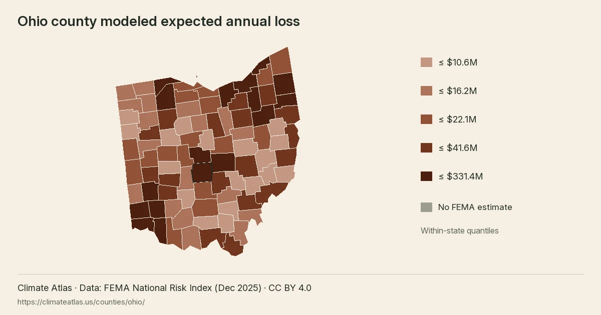
Ohio county modeled expected annual loss, in five within-state quantile classes.